 Back to the Topography Story....
Resolution limit in synchrotron topography of SiC
The resolution that can be obtained in single crystal topography experiments using the Synchrotron Radiation Source (SRS) at Daresbury laboratory is governed by geometric considerations and results from the collimation achieved at the 7.6 hutch some 80 metres from the ring. The specimen-photographic plate distance is optimised for the amount of useful high quality topographic information that can be recorded on each glass plate.
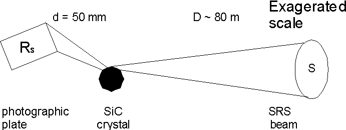
Figure 1. Diagram showing the experimental geometry at station 7.6 of the Daresbury SRS to obtain edge topographs of multipolytypic SiC (resolution Rs in the horizontal plane).
The resolution is governed by the source size S and since the divergence of the beam can be considered to be negligible q h » 0.01 mrad, the situation illustrated in figure 1 can be described approximately by the following expression:
Where R is the resolution and using some typical values ![]()
d is the specimen to plate distance, d = 50 mm
S is the source size S = 0.97 mm (1)
D is the source to specimen distance D » 80 m
R = 0.97 x 10-3 x 50 x 10-3 = 0.5 m m
80
A comparison of the resolution R in the horizontal and vertical planes for both the pre and post HBL SRS are summarised in the table below. The choice of geometry is governed by a number of factors, that due to Mardix et al (2) (vertical alignment) is particularly useful for ZnS whiskers while that due to Fisher & Barnes (3) (horizontal alignment) is particularly suited to hexagonal platelets of silicon carbide. [Note the improvement in the horizontal plane]
Table of calculated resolution R in terms of beam size S
|
Pre-HBL |
S(mm) |
R (m m) |
Post-HBL |
S(mm) |
R (m m) |
|
horizontal |
5.5 |
3.5 |
0.97 (4) |
0.6 |
|
|
vertical |
0.29 |
0.2 |
0.15 |
0.09 |
References
1. M.W. Poole Personal Communication
2. Mardix S., Lang A.R., Kowalski G. and Makepeace A.P.W. (1987) Phil. Mag. A 56, 251-261
3. Fisher G.R. and Barnes P. (1984) J. Appl. Cryst. 17, 231-237
4. Dobbing G.S. Daresbury Internal Report SRS/APN/98/126
Back to the Topography index